Storms move, shouldn’t the warnings move with them?
With 122 local National Weather Service (NWS) Forecast Offices covering the United States and its territories, NWS forecasters are responsible for protecting life and property through the constant surveillance of the atmosphere and issuing life-saving weather warnings when severe weather strikes.
When a weather warning is generated, a polygon is issued by the local NWS across the area for which the meteorologist believes the storm has the highest probability of producing severe weather. The creation of these warnings is typically based on observations from remote sensing systems like Doppler weather radar and other surface-based weather instrumentation, as well as public reports of severe weather via social media, email, or telephone.
Once the warning is issued, the storm moves through the warning polygon with time. As the storm nears the end of the polygon, the NWS forecaster must decide whether to issue a new polygon to continue warning subsequent locations ahead of the storm of a continuing threat for severe weather or cancel/allow the warning to expire due to a decreasing threat of severe weather. This piecemeal process for warning generation creates inequitable lead times for severe weather along the path of the storm – in particular for nearly adjacent locations that may fall within or just outside the warning polygon.
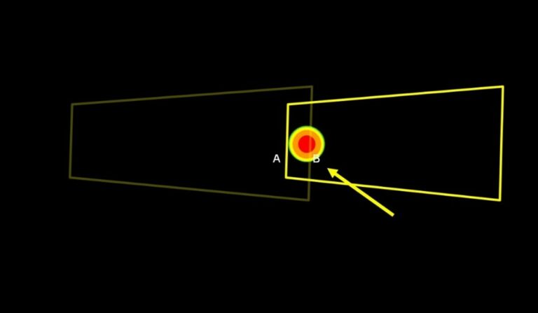
The red-target indicator illustrates a hypothetical storm (moving left to right), while the yellow polygons represent severe weather warnings (muted yellow polygon is the previous warning and the bright yellow polygon is the new warning). Note that locations A and B are nearly adjacent, yet the lead time for location A is greater than location B.
A proposed new method for warning generation is in the research and development phase that would transform static severe weather warnings to dynamic, continuously updating warnings that follow the storm. This concept, called Threats-in-Motion (TIM), is the first step in a larger initiative known as Forecasting a Continuum of Environmental Threats (FACETs) that aims to improve the forecast and warning process across all environmental hazards through the communication of probabilistic hazard information (PHI). Through several iterations of experiments with NWS forecasters utilizing archived and real-time weather scenarios, these moving warnings have been shown to create more equitable lead times and allow for improved communication as storms move downstream.
The TIM concept is expected to be introduced operationally to the NWS in phases. The first implementation that is closest to operational readiness is Tiny TIM, which will allow forecasters to extend the area and time of severe weather warnings while maintaining the same Event Tracking Number (ETN). In this regard, the forecaster can keep the same warning with the storm throughout its lifecycle – “one storm, one story” – which is especially useful with long-track, long-lived storms. Not only does Tiny TIM help reduce forecaster workload since the overall number of warnings decreases, but it will also help to eliminate overlapping warnings that can lead to communication issues in complex weather events. The capabilities of Tiny TIM will be extended with the future introduction of Taller TIM in which the warning will move continuously downstream at one-minute increments upon issuance until the forecaster intervenes to update the warning. Taller TIM creates even more equitable lead times for severe weather than Tiny TIM as well as improved departure, or “All Clear”, messaging. The final phase in this new warning paradigm will include PHI alongside these warning objects to communicate storm evolution, intensity, duration, and trend information. PHI has the potential to provide user-specific products that can be adapted to fit the needs of any individual or organization.
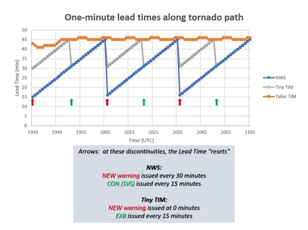
From Stumpf and Gerard (2021). Image shows the one-minute lead times along a hypothetical tornado path for current NWS warnings (blue), Tiny TIM (gray), and Taller TIM (orange). Note how lead time equitability improves with Tiny TIM compared to current NWS warnings, with even further improvement when utilizing Taller TIM.
One of the most critical elements required in the implementation of this new warning paradigm is dissemination. Through these experiments and testing, researchers are also engaging with emergency managers, broadcast meteorologists, and individuals throughout the weather enterprise from operations to the private sector to understand how to effectively relay moving, continuously updating warnings to the public. TIM represents a dramatic change in the way warning information is communicated, so it is vital to make sure that the infrastructure and partners are well prepared for the future of severe weather warnings in the United States.
Haag’s team of meteorologists have been involved in extensive field projects and research spanning the weather, water, and climate enterprise and continue to stay on top of advancements in the field. Our forensic meteorological services continue to expand and evolve with changes in our understanding of weather information. Contact one of our meteorologists today for your forensic meteorology needs.
For more information on the TIM concept, please refer to the included publication and website links:
Patrick Hyland, CCM, Senior Forensic Meteorologist
Patrick Hyland, CCM, is a Forensic Meteorologist with Haag Engineering. Mr. Hyland has over 15 years of experience in meteorology, including ten years providing meteorological consulting services for a variety of cases where expertise is required. He most recently served as a Research Meteorologist with the NOAA National Severe Storms Laboratory (NSSL) Warning Research Development Division (WRDD). He was responsible for developing cutting-edge tools, algorithms, products, and techniques to improve the warning-decision-making process for use in operational National Weather Service (NWS) Forecast Offices for the protection of life and property. He focused on radar severe weather applications, probability and impacts research, and the Multi-Radar Multi-Sensor (MRMS) system.
Any opinions expressed herein are those of the author(s) and do not necessarily reflect those of Haag Technical Services, Haag Engineering Co., Haag Education, or parent company, Haag Global, Inc.