Request a
Demo
Curious to see the Haag Geoportal in action? Fill out the form below to request a demo. We’ll walk you through the portal, showcasing how it can streamline your weather analysis and reporting.
The Haag Geoportal is your ultimate tool for accessing detailed, reliable, and accurate weather reports, enabling you to make informed decisions and analyses. Our Geoportal Reports provide comprehensive data on various storm types, including hurricanes, wind, hail, and tornado events. Data is derived from verified national weather sources and is never manipulated. The Geoportal delivers precise information tailored to your specific location and needs. Ideal for:
The Haag Geoportal combines data from several reliable sources:
Our reports cover a robust 14-year span (2010) of weather events and the Hurricane Reports include historical data from 2017 to present. The data is updated daily, ensuring you have the most accurate and historical data available.
Our reports utilize both preliminary and finalized data from trusted national and local weather sources, ensuring that the information you receive is direct and unmanipulated. This level of transparency guarantees that our data is reliable and defensible in court.
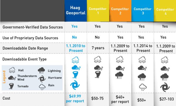
While other platforms may come with higher costs or use proprietary algorithms that can’t be justified in legal settings, the Haag Geoportal stands out. We provide direct, unmanipulated data from multiple national authorities, all aggregated into one easy-to-use interface – saving you time and increasing your efficiency.
Our reports are invaluable for professionals who need to document and verify weather events. Whether you’re assessing property damage, preparing legal cases, or conducting forensic analysis, the Haag Geoportal provides the accurate and reliable data you need.

The Haag Geoportal Hurricane Reports utilizes the most recent storm data from the NOAA National Hurricane Center for the Atlantic and Eastern Pacific basins. This includes:
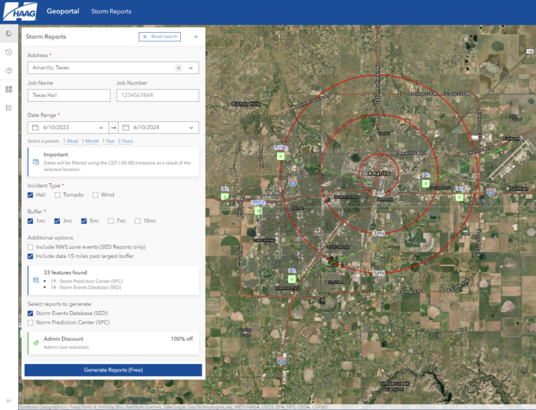
With the Haag Geoportal, you can create a free account and search for specific sites by address. View weather data directly on an interactive map, and when you need deeper insights, purchase a comprehensive report for just $49.99 (per report). Our PDF reports provide tabular results, detailing point distances from your site location to weather events within your selected buffer zone and providing specific information for events that match your search criteria.
Wind, hail, and tornado events
Hurricane and tropical events
Other platforms offer weather related data services, but they often come with higher costs or use proprietary algorithms that can’t be justified in court. The Haag Geoportal stands out by providing direct, unmanipulated data from multiple national authorities. Our platform simplifies the process by aggregating verified weather data into one easy-to-use interface, saving you time and increasing your efficiency.

In each of the Storm Reports, the following data is available to include when applicable:
In each of the Hurricane Reports, the following data is available to include when applicable:
While our reports provide comprehensive data, an on-site inspection is the best way to understand what actually occurred at your site. Lack of storm report data does not necessarily mean that severe weather did not occur, as data can vary based on population density, time of day, concurrent weather hazards, etc. For a formal investigation and/or forensic meteorological analysis, contact our forensic meteorology team. All our meteorologists have obtained their Certified Consulting Meteorologist (CCM) designation or work under direct supervision of a CCM. Meteorologists who obtain a CCM must pass a rigorous examination process exhibiting a high degree of technical proficiency and moral character.
Haag has been delivering forensic meteorology services for over 40 years. Our team has a deep understanding of how weather impacts a building’s performance and the surrounding environment. Closely integrated with our forensic engineering team, our meteorology experts bring a specialized focus to every assignment, analyzing weather-related impacts on structures and providing comprehensive insights across the entire built environment.
Unlock precise weather history for your property with the Haag Geoportal. Access reliable, verified data and streamline your weather data analysis process. Sign up today and experience the difference accurate weather reporting can make.
We’re here to help you make informed decisions with confidence.
Curious to see the Haag Geoportal in action? Fill out the form below to request a demo. We’ll walk you through the portal, showcasing how it can streamline your weather analysis and reporting.
Enter your personal information and project specifics to get started.