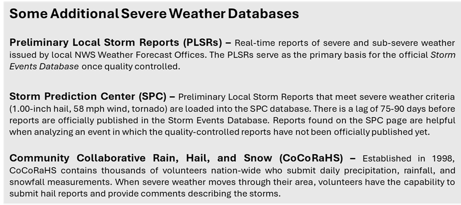
Storm Reports: how do we use them? (Part 2)
In Part 1 – Storm Reports: Where Do They Come From – we discussed the various sources of obtaining storm report information. In Part 2 we will show an example of how Haag Certified Consulting Meteorologists can supplement official storm reports with information provided by other hail report databases to increase detail in the analysis of a complex severe weather event.
A recent hail event near St. Louis, Missouri highlighted the utility of using Preliminary Local Storm Reports (PLSRs) and Community Collaborative Rain, Hail, and Snow (CoCoRaHS) reports in analyzing a hailstorm. The official National Centers for Environmental Information (NCEI) Storm Events Database entries for this event contained a handful of hail reports across the St. Louis metro, some of which were entered into the database as hail swaths, despite the NWS receiving dozens of additional hail reports. Keep in mind that the primary objective of the NWS is not necessarily to document every instance of reported severe weather into the Storm Events Database, rather it is to officially document enough reports to adequately verify the severe weather warnings that were issued. So, at times, it is appropriate for NWS offices to consolidate multiple hail reports, concentrated in a relatively small area, into a single hail report or hail swath when entering this data into the Storm Events Database. This is especially prevalent in densely populated, metropolitan areas where sometimes dozens of hail reports are made across just a few city blocks.
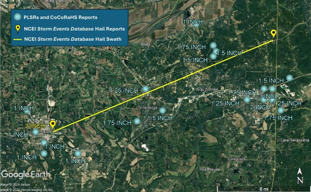
For the event in St. Louis, one of the NCEI Storm Events Database hail swath entries indicated that the largest hail stone within the swath was 3 inches. The storm report included a beginning and ending point for that swath of hail shown as the yellow line below. Note, however, that 3-inch hail was not observed along the entire length of that swath. Additionally, by consolidating the reports into this swath, information on the distribution quantity and magnitude of the additional hail reports across this area was lost. These additional hail reports are shown in blue.
Event Narrative: A wide swath of large hail fell across Franklin County from Union through Villa Ridge, Grey Summit and Pacific. The largest hail stones, 3 inches in diameter, were reported on the north side of Pacific.
NCEI Storm Events Database hail reports (yellow) for a single hail swath overlaid with PLSRs and CoCoRaHS reports (light blue), along with Storm Events Database Event Narrative for the hail swath.
When the official Storm Events Database is combined with the other hail report databases, such as PLSRs and CoCoRaHS for this thunderstorm across St. Louis, more information about where, when, and how large the hail occurred becomes available, which along with careful radar analysis, provides useful detail.
It is important to remember that these databases are not fully quality-controlled, so while these reports are mappable and publicly available, the lack of a quality control process means that they could be prone to errors. When these reports are combined with sound analysis by an experienced meteorologist, they can help provide details into events otherwise not made possible by using solely the official Storm Events Database. Haag Global, Inc. is proud to have four active American Meteorological Society Certified Consulting Meteorologists (CCMs) on our team, with expertise and applied experience in all weather phenomena. With our meteorologists you can be sure that your assignment will be handled with the highest level of professionalism, expertise, and ethical standards.
Author

Jared Leighton, CCM, FORENSIC Meteorologist
Jared Leighton, CCM, is a Forensic Meteorologist with Haag Engineering Co. Based near Kansas City, Jared Leighton has over 16 years of experience in meteorology. He has spent the last decade as Senior Forecaster for NOAA National Weather Service in Kansas City, Missouri, and as a General Forecaster and Meteorological Intern prior to that position.
Mr. Leighton has extensive, comprehensive experience in NWS forecast operations across multiple geographic areas, including frequent supervision of severe and winter weather watch and warning operations. He regularly conducted storm surveys, both solo and as storm survey team lead, including multiple tornadoes in Kansas and Missouri, as well as the severe weather event on September 15, 2010, in which 7.75 inch hail occurred in Wichita, Kansas (the second largest certified hailstone recorded in the US). Mr. Leighton led and participated in several research teams, resulting in five peer-reviewed formal publications as well as presentations at local, regional, and national conferences. He also organized local storm spotter training in coordination with emergency management and led the Storm Ready community preparedness program.
Mr. Leighton earned a Bachelor of Science degree in Atmospheric Science from the University of California Davis. He is an American Meteorological Society Certified Consulting Meteorologist (CCM #783).
Any opinions expressed herein are those of the author(s) and do not necessarily reflect those of Haag Technical Services, Haag Engineering Co., Haag Education, or parent company, Haag Global, Inc.